Details
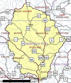
The 188.5 square mile Upper Pine River watershed lies mostly in north central Richland County with a small portion in Vernon County. Streams in the watershed have a high gradient and water quality is generally good. Nearly all of the streams in the watershed are cold water streams and can support trout and other cold water species.
Like other watersheds in the Lower Wisconsin Basin, agriculture is the dominant land use in the watershed. Currently, the overall trend in Richland County is from intensive agriculture to hobby farming. The exception to this transition in land use is near the upper end of the Pine River. There are few wetland complexes in the watershed. Many of them are wet meadows adjacent streams that have been degraded by grazing or cultivation. One exception to this is a northern bog wetland complex near Hub City. This type of wetland is very rare in this part of the state.
Despite the generally good water quality in the watershed and the transition from intensive agriculture to less intensive hobby farming, there are still some water quality, habitat and recreational use problems in the streams as a result of nonpoint sources of pollution. As a result of this nonpoint source pollution, some of the cold water and trout streams are in poor condition.
Date 2001
Population, Land Use
The watershed is estimated to have a population of around 4,975 people. The Village of Yuba is the largest municipality in the watershed and experienced 19.5% growth in the last decade from 77 people to 92.
Date 2001
Nonpoint and Point Sources
There are two permitted point source discharges in the watershed. The Hub City/Rockbridge Sewerage District discharges to the Pine River. In addition, Foremost Farms also has a permit to discharge to the Pine River and to groundwater.
Date 2001

Ecological Landscapes
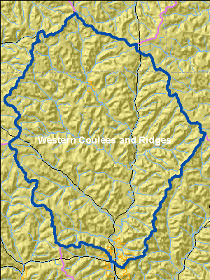
The Western Coulee and Ridges Ecological Landscape in southwestern and west central Wisconsin is characterized by its highly eroded, driftless topography and relatively extensive forested landscape. Soils are silt loams (loess) and sandy loams over sandstone residuum over dolomite. Several large rivers including the Wisconsin, Mississippi, Chippewa, Kickapoo and Black flow through or border the Ecological Landscape.
Historical vegetation consisted of southern hardwood forests, oak savanna, scattered prairies, and floodplain forests and marshes along the major rivers. With Euro-American settlement, most of the land on ridgetops and valley bottoms was cleared of oak savanna, prairie, and level forest for agriculture. The steep slopes between valley bottom and ridgetop, unsuitable for raising crops, grew into oak-dominated forests after the ubiquitous presettlement wildfires were suppressed. Current vegetation is a mix of forest (40%), agriculture, and grassland with some wetlands in the river valleys. The primary forest cover is oak-hickory (51%) dominated by oak species and shagbark hickory. Maple-basswood forests (28%), dominated by sugar maple, basswood and red maple, are common in areas that were not subjected to repeated presettlement wildfires. Bottomland hardwoods (10%) are common in the valley bottoms of major rivers and are dominated by silver maple, ashes, elms, cottonwood, and red maple. Relict conifer forests including white pine, hemlock and yellow birch are a rarer natural community in the cooler, steep, north slope microclimates.
The Upper Pine River Watershed has a variety of good quality habitats and rare plant communities that are listed on the state's Natural Heritage Inventory, (NHI), which is kept by the Bureau of Endangered Resources. These communities include: dry cliff, hemlock relict, moist cliff, pine relict, southern dry-mesic forest, southern mesic forest, alder thicket, northern wet forest, shrubb-carr, and southern sedge meadow.
Date 2001
Wildlife and Habitat
In addition to these special communities, the watershed is also home for a variety of rare plant and animal species including; 2 species of fish, 12 plant species, 1 species of snake, and 1 mammal species. These plants and animals are also listed on the state's Natural Heritage Inventory (NHI).
Date 2001
Watershed RecommendationsVernon County Nonpoint Source BMPs
Date
Status
This project is a landowner installation of nonpoint source best management practices to contribute to the restoration of Wisconsin's waters and was funded by the 319 grant.
6/4/2018
In Progress
Vernon County NOD
Date
Status
This project is a landowner installation of nonpoint source best management practices to contribute to the restoration of Wisconsin's waters and was funded by the 319 grant.
6/4/2018
In Progress
 Watershed History Note
The City of Richland Center is located within the Willow Creek Watershed and the Upper Pine River Watershed. The city was originally platted in 1851. By 1854, Ira Haseltine, one of the city's founders, had erected a dam which provided water power to both a sawmill and a grist mill. The city primarily served an agricultural community until the railroad came to town in 1876, at which point the lumber milling industry took off, followed by the commercial cheese and dairy business.
The historical development of Richland Center as an agricultural support community and retail trade center is reflected in its fine architectural heritage. Buildings dating from as early as the mid-1850's and 1860's still remain in the city. The greatest wealth and diversity shown in the city's architecture dates from the late nineteenth and early twentieth centuries when Richland Center experienced rapid growth and prosperity.
Richland Center was the birth place of Frank Lloyd Wright in 1867. The city organized one of the first local suffrage organizations in 1882, built a modern city hall in 1911 and on January 1. 1952, cable TV was installed in Richland Center where a group of citizens gathered to watch the Wisconsin Badgers play in the Rose Bowl. This was the second cable TV to be installed in the State of Wisconsin.
Date 2011